TRANSPORTATION
The West Virginia Hardwood Alliance Zone is within a 500-mile radius of 50% of America’s population and 30% of the Canadian population. We have ready access to markets and multiple modes of transportation to lessen the supply chain distance and to transport your products and goods.
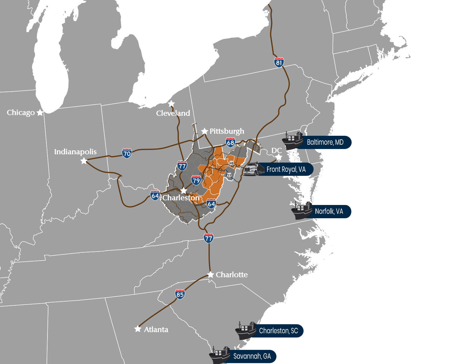
Interstates: There are 5 primary interstates that cut through or are in proximity to the HAZ to help transport your goods to market.
Corridor H: U.S. Route 48, also known as the incomplete Corridor H of the Appalachian Development Highway System, extends from Interstate 79 in Weston, West Virginia eastward across the crest of the Allegheny Mountains to I-81 in Strasburg, Virginia. It is planned to extend 157 miles from northwestern Virginia to central West Virginia.
I-68: is a 112.9-mile Interstate Highway in the US states of West Virginia and Maryland, connecting I-79 in Morgantown, West Virginia, to I-70 in Hancock, Maryland. I-68 is also Corridor E of the Appalachian Development Highway System.
I-79: Interstate 79 is an Interstate Highway in the eastern United States, designated from I-77 in Charleston, West Virginia north to Pennsylvania Route 5 and PA 290 in Erie, Pennsylvania. It is a primary thoroughfare through western Pennsylvania and West Virginia and makes up part of an important corridor to Buffalo, New York, and the border with Canada.
I-81: Interstate 81 crosses the Eastern Panhandle region, linking Virginia to Maryland. The Interstate Highway spans 26.00 miles through Berkeley County, paralleling U.S. Route 11 for its entire length. I-81 enters the state near Ridgeway and travels northeast, bypassing the city of Martinsburg, and leaves the state at the Potomac River.
I-64: I-64 travels for 184 miles, passing by the major cities of Huntington, Beckley, and Lewisburg and directly through the capital city of Charleston. It has only two major junctions within the state: I-77 in Charleston and in Beckley.
Port Authorities: Having access to multiple ports helps reduce travel times and the cost of transportation of goods. These following ports are within a one-day’s drive or less than 500 air miles from the Hardwood Alliance Zone:
Front Royal – This inland port connects directly to Corridor H from I-81.
Maryland Port Administration
Port of Virginia:
South Carolina Port Authority
Georgia Ports Authority
Jacksonville Port Authority
Commercial Airports: Air transportation is essential to businesses by providing air shipment of products and access to air travel for passengers. There are a number of airports that serve the Hardwood Alliance Zone and we are just a few hours from several international airports
| City | Airport |
|---|---|
| Charleston, WV | Yeager Airport |
| Clarksburg, WV | North Central West Virginia Airport |
| Huntington, WV | Tri-State Airport |
| Lewisburg, WV | Greenbrier Valley Airport |
| Morgantown, WV | Morgantown Municipal Airport |
| Parkersburg, WV | Mid-Ohio Valley Regional Airport |
| Arlington, VA | Reagan National Airport |
| Pittsburgh, PA | Pittsburgh International Airport |
| Washington D.C. | Dulles International Airport |
Railroads: Railroads are some of the most efficient modes of transportation for moving product across large distances. The Hardwood Alliance Zone is serviced by a number of different freight systems.
COMMON FREIGHT CARRIERS
- Appalachian and Ohio Railroad
- Beech Mountain Railroad
- CSX Transportation
- Elk River Railroad
- Norfolk Southern Railway
- R.J. Corman Railroad/West Virginia Line
- South Branch Valley Railroad
- Winchester and Western Railroad